Defining maptypes
Maptypes show the map in their own specific way. From the original street map,
to a view on Mars. It is all possible. For a complete list check the
API.
API
Screenshots
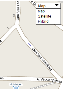
| useMenu="true" |
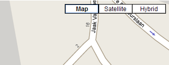
useMenu="false" |
 |
 |
Code
<rd:map mapId="map_canvas" width="700px" height="500px" key="abcdefg" autoCenter="true" mapControl="none">
	<rd:marker id="marker01" name="RealDolmen Huizingen"
	address="A. Vaucampslaan 42" city="1654 Huizingen" country="Belgium">
		<rd:infoWindow for="marker01" text="RealDolmen HQ"/>
	</rd:marker>
	<rd:mapTypeControl useMenu="true" hybridMap="true"/>
</rd:map>
